9. Vermont
Highpoint # 9
Mount Mansfield, 4,393 Feet (26th highest)
September 14, 2003
# 24 on the New England Hundred Highest/NE 4000 Footers Peaks Lists
Less than a week after conquering what was our most challenging highpoint to date (Katahdin), Vermont’s Mount Mansfield almost seemed like an afterthought. I knew it wasn’t a joke of a mountain, and with the dawn sky looming gray and gloomy, I knew this hike wasn’t high on Hoang’s “to do” list. So far, we had been relatively lucky weather-wise on our previous trips; sure, it was poor for Rhode Island, but that was a three minute walk – true, we had been spared being exposed to truly bad weather. After a long week of vacationing in Quebec City, Montreal, and Burlington, VT – replete with rich French cuisine, high falutin’ Bauhausian hotels, high-end fashion shopping and champagne sipping – climbing a northern Vermont mountain in a chilly rain wasn’t sitting well with either of us.
Badass highpointing Babe in Burlington the night before… (Though, that’s not really Mansfield in the picture, but is in the below shot.)
I tried my best to pump Hoang up and to be positive, but we were both tired and we knew it. Thankfully, Katahdin was last weekend instead of the other way around; I think Hoang would have thought about pushing me off a cliff if I had planned the trip that way! As it turned out, the weather really wasn’t too bad, as it wasn’t raining, nor was it too hot or too cold. We had arrived at the Ski and Sun Inn in Stowe late the night before (“You’re the last to arrive,” we were told by the creepy Norman Bates look-a-like at the front desk), so it was somewhat strange to be up and eating our, “free” breakfast at 6:45AM (“You’re the first,” we were told by the Kathy Bates look-a-like manning the coffee pot).
The drive to the trailhead was only a few miles north and the sky was not as ominous as it looked upon our waking an hour earlier. Hoang was still a tad grumpy, but that’s perfectly normal for her early in the morning (It’s actually a rather cute and somewhat endearing trait). I continually tried to make her feel better about the impending climb, peppering her with, “This will be nothing after last weekend,” “A walk in the park,” and, “We’ll be on top in no time!”
We were going to be climbing from the north, on the fabled Long Trail of Vermont off of highway 108, just outside of Stowe. The Long Trail traverses the length of the state, south to north and is 265 long. About 100 miles of the southern portion is also the Appalachian Trail, but not where we were hiking. (The Long Trail was built before the AT, and served as an inspiration for it).
While we weren’t on the AT this day, I think it’s important to note that we’ve now done 4 of the 6 highpoints that the Appalachian Trail comes within a half mile of – NJ, MA, NH, and ME (the two remaining are TN and VA… 2006 perhaps?) Also, Mt. Mansfield is yet another possible drive up that we – ok, I – chose to ignore. The Stowe ski resort is built on this massively long mountain, which is said to resemble a man’s profile lying down. It is perhaps the worst representation of that I’ve ever seen (brow, nose, chin, and Adam’s apple)… One would have to see the world in purely Picasso-ian terms to see the “profile.” Our goal was to summit the “chin,” which is the highpoint of Vermont. Most of this hike would be under the canopy of sugar maples and birch trees at first, then evergreens, as opposed to Katahdin’s exposed ridgeline, which certainly offered some respite and comfort.
The first few miles were rather enjoyable and not too difficult. Nowhere did the climb approach being anything like Katahdin… in fact, it wasn’t even initially as steep as Frissell (CT), and certainly not as rocky as Mt. Washington (NH). The gray skies were still casting a pall over the hike though, as the outcroppings on the way up offered nothing in the way of views – which was lame. The maple leaves in northern Vermont were just starting to change over to the vibrant reds and oranges for which New England is famous. If only we were here a week or two later, this hike would have been breathtaking. Oh well… I was still having a great time.
As the miles ticked off beneath our feet, Hoang’s spirits were slowly improving. We had goals to reach along the way such as the Profanity Trail, which is a more direct (read: steep, as we learned at Greylock) route to the summit. Apparently the name was derived from those who were on the summit when bad weather hit and they had to scramble down to safety, cursing all the while. Also, just before tree line sits the Taft Lodge, a large log cabin for Long Trail thru hikers and Green Mountain caretakers. Although the hiking was not difficult, I was constantly under the impression that the lodge would be, “Just over that hump,” and, “Just around the corner up ahead.” I’m usually pretty good at judging distances and with gut feelings, but for some reason on Mansfield, I was way off. I think I was just eager to complete the climb, get back down to the car, and head home.
Just before reaching the lodge, we passed two women in their twenties coming down. What struck me about them was not their shimmering hair, lipstick, eye shadow, or carefully measured steps, but rather their full internal frame packs. You’d think with all that gear that they were Long Trail thru hikers, but their looks certainly belied that theory. Later, we found out from a summit caretaker that they were just overnighters who stayed in the lodge! Women!
The lodge itself was very well constructed and rather homey. No one was around, so we took a quick snack break, lamented the complete lack of views, and tried to get excited for the last 2/3 mile of exposed hiking left to complete. (Poking around the Internet, I’ve noticed that almost everyone’s Mansfield trip reports are all equally cloudy and miserable. I know we got lucky on Mount Washington, but after the bum deal we got last week on Katahdin – crystal clear the day before and the day after- I thought we’d luck out in Vermont). Just past the lodge, we entered into a small mountain meadow, which was a nice transition area between the trees and the exposed top portion of the mountain. At this point, we were almost able to see our goal: the “chin” of Mt. Mansfield.
Yeah, we’d be climbing straight up that… and yeah, there were sheer drop-offs
A short while later, we were confronted with a few rock scrambles that were more or less straight up. I admit I was a bit surprised at some of the drop-offs along the sides of the trail near the summit. Once again, I felt for my wife who is not very comfortable when faced with sheer cliff faces just a misstep or two away. But once again, she did me proud and chugged along right in front of me. One thing about Hoang, she is one of the most determined and strong-willed people I’ve ever known.
Once on top of the ridge, it was an easy jaunt through a fragile alpine meadow to the actual summit – highpoint number 9 in the books, baby. There were a few people milling around, trying to stay warm and out of the stiff wind. We spoke with the ranger stationed on top (bear in mind, there is a road up to the ridge, which still requires a decent little hike to the summit proper, but nothing difficult as it’s a flat ridgeline) for a while who couldn’t have cared less about this thing called highpointing. Her loss. She did snap our photo and did feel sorry for us about the clouds and lack of any view whatsoever. We rested for a little while, ate some trail mix, and immediately thought of getting back to the car. Hoang is much, much happier about going down than up, as she practically runs down the mountains – despite the Mauna Kea breathing difficulty!
Just as we got off the summit proper and began gathering ourselves for the descent, an amazing thing happened. In an instant, the clouds started breaking up towards the northwest. Suddenly, valley farms became visible below, the “Adam’s Apple” appeared towards the north, and patches of blue were popping up overhead all over the place. It was really really amazing… and beautiful. When hiking, you realize how happy simple things make you feel, and this was no exception. You can see the actual, honest to goodness joy on my face in the pictures below… as it comes over me from an initially bummed out summit photo.
In a matter of about 3 minutes, the summit went from dark and gloomy with 100 yards of visibility, to an almost cloudless, sunny and warm spectacle…
Me, positively bummed…
Hoang, definitely bummed…
Me, slightly less bummed…
Two minutes later, me, getting happy…
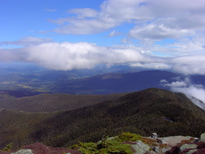
Because this is what we saw in the next minute. One of my favorite hiking pictures ever.
I’ve done a lot of climbing in my day, and I had never seen anything like that before. Hoang quickly appreciated the effort put in to the climb, as we silently sat for several minutes, just soaking in the views of the Adirondack high peaks to the west. “I’m sure one of those mountains is Mt. Marcy,” I said, already prepping Hoang for the last of the northeast highpoints to be hopefully summitted next September.
“I can’t wait! That will be the day I look forward next year more than any other,” exclaimed Hoang.
“Whoa, not so fast… what about our Spring trip to knock off SC, GA, and AL?”
“Too much, too much,” she said, “You give me too much pleasure to deal with all at once.”
“I know baby, I know… but you’ll be ok. Now let’s get on home to Connecticut.”
“Awww, man… this was a great hike and a great vacation. Is there anything else we could possibly do that I’d enjoy before going back to work tomorrow?”
“Oh, just you wait…
Pleasure overload at Ben and Jerry’s HQ in Vermont… Suddenly, it was all worth it.
…………………………………………………….
Highpoint Difficulty Rating: 5
Hike Distance: 4.6 miles
Distance from Current Residence (West Hartford, CT): 230 miles


Leave a Comment