Lake Chargoggagogg…maugg
Lake Chargoggagoggmanchauggagoggchaubunagungamaugg
Thompson, CT & Webster, MA
June 3, 2011
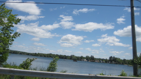
Lake Chargoggagoggmanchauggagoggchaubunagungamaug is one of the longest words in the English language (that’s a stretch) and certainly one of the longest place name in the world. Lake Chargoggagoggmanchauggagoggchaubunagungamaugg is a 1,442-acre lake with a 17-mile shoreline. Lake Chargoggagoggmanchauggagoggchaubunagungamaugg has about 7-8 islands. Some 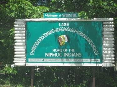 have houses and are habitable; a few are extremely small and uninhabitable.
When I originally planned on “visiting” this lake and posting about it on CONNECTICUT MuseumQuest, I meant to have my rare “Not-In-CT” alarm go off. This alarm is for the few things that are CTMQ-worthy but aren’t in Connecticut – like my visit with Damian to Campbell Falls within sight of the border with Massachusetts, among others.
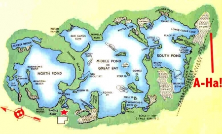
But as I stared closely at some maps, I realized two things: That you can see this absurdly named lake from the far northern reaches of Thompson, CT AND, more importantly, the cedar swamp on the southeastern end of this ridiculously named lake DOES bleed into Connecticut. And, in theory, after some seriously heavy rain, you could maybe, just maybe, slog a canoe from the lake proper to the swamp proper without realizing you’d crossed state lines. So… no “Not-In-CT” alarm this time.
Of course, the only reason I’m hastily writing this page (the videos at the bottom tell the story better than I am) is because of the wackadoo name. And, as you’d guess, there’s a story about it. From OldeWebster.com:
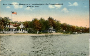
(Picture below left from this cool guy who rode his bike across the country.
 From the days when the big lake with the longest name in the United States was a central gathering place for the Nipmuc Indians and their friends, the great pond – divided by narrow channels into three larger bodies of water – has been famed throughout the area.
The Indians had several different names for the great body of water, as can be learned from early maps and old historical records. However, all of these were similar in part and had almost the same translation, according to Indian language. Among early names were Chabanaguncamogue, Chaubanagogum, and Chaubunagungamaug, the latter now incorporated in the long name.
 All historians – and Indians of this and other territories – have agreed that Chaubunagungamaugg means “Fishing Place at the Boundary”.
[The old postcard to the right is from... I forget. Darn. I hate that. But it's not mine, of course and I'm sorry to the old postcard website I took it from.]
One of the tribes on the other side of the lake was the Monuhchogoks, which was corrupted to the name Manchaug. A map of 1795, showing the town of Dudley, indicated the Lake name as “Chargoggaggoggmanchoggagogg”. In 1831, both Dudley and Oxford, which adjoined the lake, filed maps listing the name of the pond as Chargoggagoggmanchoggagogg, but a survey of the lake done in 1830 lists the name as Chaubunagungamaugg, the ancient name.
Authorities have indicated that the development of the name to the present long form stems from the time Samuel Slater began his mills near the lake, which was nearer the Manchaug village. Hence the Indian designation Chargoggagoggmanchauggagogg meaning “Englishmen at Manchaug,” came into use. Later they added their original Indian descriptive name, and the entire designation becomes “Englishmen at Manchaug at the Fishing Place at the Boundary” — or Lake Chargoggagoggmanchauggagoggchaubunagungamaugg.
 Despite this official knowledge, the lake – now descending too often to the designation of Webster Lake – is known the world over by the humorous translation “You Fish on Your Side, I Fish on My Side, Nobody Fish in the Middle”.
As far as is known, the great publicity attained by this translation and the length of the name, stems from a story once written by Larry Daly, editor of the Webster TIMES, and widely picked up by other papers and magazines. In his humorous article about the Lake and the Nipmucs, and the disagreement over the translation, he submitted his own translation – which is now more freely accepted than the authentic meaning.
In the days of the Indians, the lake was a noted fishing place. The tribes gathered there for their pow-wows.
The coming of the white man changed that kind of gathering, but throughout the years, the lake with the long name has continued to attract thousands of people to its shores each summer.
Nice going white man. Even if, as I read it, you’re responsible for this lake being the least bit famous with your silly translation. In fact, there are songs and poems and all sorts of fun stuff that has cropped up around the lake.
I happen to think it’s all pretty cool. And if the attendant videos below are any indication, so does the rest of the world.
Poem “Evolution” about the lake
Lovely Lake Chargoggagoggmanchauggagoggchaubunagungamaugg song
Lots more about the lake
I somehow missed this sign and I’m mad.
The BEST Lake Chargoggagoggmanchauggagoggchaubunagungamaugg video. Watch this.
Fox News reports on the misspelling
CBS News with Katie Couric on the lake.
Longest English words


Thanks for the explanation! We pass this every time we go to my brother’s house and I always meant to look it up. Any tips on pronunciation?
Comment #1 on 06.06.11 at 2:37 pm“Webster Lake” works pretty well.
The CBS linked video has a guy rattling it off pretty well.
Comment #2 on 06.06.11 at 2:53 pmHmmmm … based on Google Maps satellite views I am not quite sure that the canoe-after-heavy-rain theory would suffice in making the lake part of Connecticut. Here is a link to the page, I hope it shows up okay (there’s no Preview function).
What appears to be a dirt road or path runs *just* north of the state line eastward from the point at which Jackson Road dips below the state line. While the swampy areas extend southward into Connecticut, I would imagine that this road/path blocks canoe access to the lake no matter how high the swamp’s water level may be. (Note: the bird’s eye view on Bing Maps shows this path more clearly, however the state line isn’t indicated.)
A short distance to the west, just before the intersection with Black Point Road, Jackson Road dips slightly to the south, just enough so that the roadway seems to be in Connecticut. For a stretch of probably no more than 50 to 75 feet there is no roadway or other development between the Connecticut line and the lakeshore. Unfortunately, the land in between looks to be dry and partially wooded, no doubt making a portage-less canoe journey impossible.
Comment #3 on 06.07.11 at 12:40 amWhy I oughtta… How about this – this lake is dam-controlled. It looks to me like those areas just north of Jackson Road were historically part of the lake, but the level they keep it at now disallows that. So maybe 50 years ago the water lapped upon CT’s fair border.
Or… I think I could throw a perfectly shaped rock from CT into the lake maybe on a good day.
Or… If you had a chance to write about this ridiculous lake name, wouldn’t you bend the CTMQ-rules (that don’t really exist) too? Heck, my Southwick Jog page is one of the most read and that’s MA too!
Comment #4 on 06.07.11 at 9:45 amWait a minute … I think it may be possible for Connecticut to claim a share of the lake without having to resort to stone throwing or canoe portages. You can see this more clearly on Bing Maps, unfortunately, as I’ve noted, it doesn’t appear possible to link directly to the relevant page. Go to the extreme southwest corner of the lake, close to where the state line crosses Route 193. Just to the south of Bates Crossing is a small pond, perhaps one-quarter to one-half acre in size. It appears as a wetland on Google Maps, so most likely it’s seasonal depending on rainfall levels.
Two things about this pond are relevant to our discussion: a) it probably (almost certainly?) is connected to the main body of the lake by a culvert under the road, and therefore would be considered part of the lake in hydrological terms, and (b) its southern tip may dip ever so slightly into the Nutmeg State.
Comment #5 on 06.07.11 at 2:32 pmThe white translation is reasonably accurate the lake was a peace boundry for several local tribes.Knowing that fish from this lake was a vital food source for every one a truce was agreed to here by the local natives, If enemy tribes met here they would simply stay on separate sides of the lake and each would fish in peace at those times “no man would fish in the middle” thus purposely staying away from each other.
Comment #6 on 10.29.11 at 2:33 amThere were some times when a small boat or canoe could be used to get from the swamp area in Ct. directly to Webster lake.We used to call this area Jerries Swamp and it was a favorite spot for us to fish, camp and just hang out what some people call a road was rail bed for the trolley tracks to Webster and beyond.the swamp was always a few feet deep and there were a couple times in spring when the water was high a small light boat could be coaxed over to the mass side
Comment #7 on 10.29.11 at 2:39 amI’ve read numerous and fascinating books on the Native Americans who inhabited the area. The Nipmucs played an important role in Metacom’s (or King Philip’s) War in 1675 -1676. The lake is never mentioned as a neutral meeting ground. The dams (2)built by Samuel Slater or someone earlier, perhaps in the mid to late 1700′s enlarged the lake to add water power. In fact, North Pond was totally separate from the rest of the lake at one time. The Old Connecticut Path crossed the lake at “The Narrows” and separated North Pond. The swamps became part of the lake after the dams flooded these forested areas with at least 4 feet, maybe more, of water. In 1600 there were 15,000 Nipmucs in the area.
Comment #8 on 09.07.12 at 7:59 pm