Section 8: The Good, The Bad, And The Ugly
Metacomet Trail: Section 8
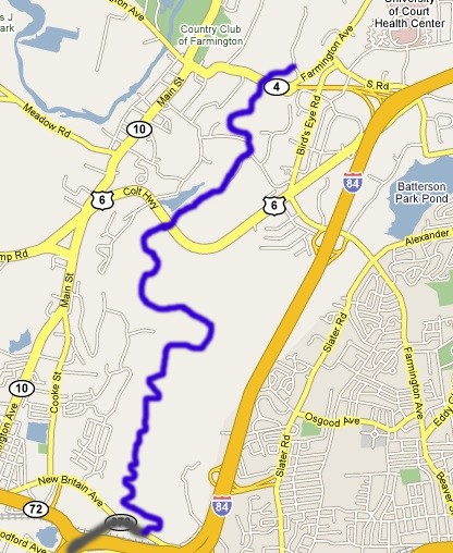
Rte 372 Oval Sign to Prattling Pond Road, 6.3 miles, Farmington
October 6, 2007
 The Metacomet Trail just gets better and better. Another perfect day for a hike with more surprises along this fascinating section. These include a couple dangerous road crossings, some beautiful overlooks, an abandoned Nike missile base, a storied colonial cave hiding place, gigantor TV towers, museum property (only fascinating to CTMQ), and – I don’t know which is more interesting – wild Connecticut cacti or rapper 50 Cent’s mansion? All this in little over 6 miles!
The last section ended with a long 1.6 mile road walk; initially through woods, then houses, then a busy road, a busier intersection, a bridge across an interstate highway, two gas stations, and finally an industrial string of non-descript buildings. As a result, Hoang and I were eager to get back into the woods.
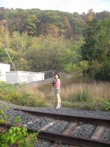
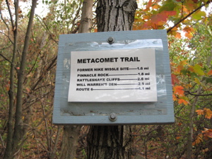
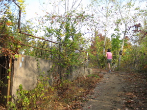
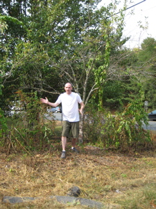
We took the traditional starting picture Hoang (above right) – oooh, pink shirt today, that’s nice. And away we went… The first blaze of this section is on the ground – in the middle of a railroad tie. The next several are blocks of wood along a chain-link fence edging slightly uphill. That was all odd enough… then we came upon this sign:
“Former Nike Missile Site” what? How hadn’t I ever heard of this before? Oh well, it wasn’t far away so I’d be able to check it out soon enough. We hiked a little steep section (true to Metacomet standards, this lasted all of 100 feet or so) and reached a little very broad plateau. A strange gasoline smell permeated the air, reminding us that we were very close to homes and businesses.
A jog to the west and we were treated to our first view of the day – I-84, 72, and 372 wound below us, with the sand factory not too far away. Ahhhh… The morning fog was beginning to lift a bit, so we edged forward toward the cliff.
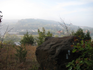
The view out over the concrete valley wasn’t the best but then I looked down at my feet and was very puzzled…
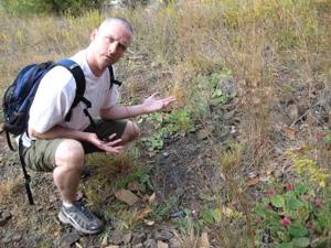
See? Look how puzzled I was. And if you can’t make out what I was puzzled about in the picture above, the following two pictures will make it abundantly clear.
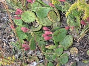
Wicked

Cool
That, my friends, is wild Connecticut Prickly Pear cactus. Something that in my ignorance, I would never have believed unless I saw it with my own eyes. (In fact, I’ve told a few people most of whom simply refuse to believe what is in the three pictures above. Since it’s so easy to access, they can go check it out themselves.) Perhaps this offers more of an authority on the matter.) It’s okay to be surprised, Hoang and I certainly were.
The next mile or so of the Metacomet is really cool. It twists and turns trying its darndest to stay on the closest thing to the ridgeline as possible. That means criss-crossing a Jeep trail about 27 times, which does get a little bit annoying. The Jeep trail of course takes the simplest, flattest route while the trail just swings wildly back and forth to go up and down every little basalt blip possible. This, of course, allows for some photo ops:
As well as some shots of Hoang looking good chugging up an incline:
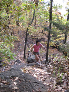
Some of the trail blazing was a little absurd, as we could follow the Jeep trail with our eyes the entire time… but we stayed true to our promise of red-lining the entire Metacomet (that is, not missing a step of it) and followed each and every seemingly silly twist and turn. By doing so, we were treated to the first of what would be many overlooks, with views of Plainville, CT below.
Unfortunately, with the accessible Jeep/ATV trails came idiots with cheap beer and a penchant for building fires and littering. This was the first (and most likely last) section of the entire trail that was marred with lots of litter, graffiti, and rutted out tracks. it wasn’t unbearable, but some sites weren’t too pretty either.
Super Hoang inspects the scene
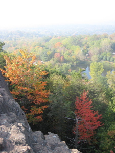
As you’ve discerned by now by the date of the hike and looking at the pictures, Autumn had finally come to southern New England. Since we’ve been in drought conditions for several months, the foliage this year is the worst it’s been in a long, long time. The day of this hike was about a week before typical peak foliage time, and as you can see, it’s pretty weak. That said, it is still beautiful here in the Fall and one of the reasons I really enjoy New England.
After a mile and a half of the winding trail over every little nub, rise, ride, and bump, we reached the site of the former Nike missile site. These things are all over the East coast and I know of at least 2 others in Connecticut. Here, though, there is no longer any structure or building, just a large concrete platform and some fencing. The trail goes right up and over the site.
There is a rock outcropping directly at the site with nice views west and north. Unfortunately, there is also a rather passable road to this point so there were beer bottles and cans everywhere. I imagine keeping this place clean would be imposssible; so I won’t complain about it. Every kid from Plainville or New Britain probably makes it up here at one point or another. The only problem is that some litter marred this otherwise lovely shot:
Note there faintly in the background are two very large TV antennae. One can see these things for miles around central Connecticut and I had known since starting this hike that they were along the trail. Seeing them every day, twice a day, on my commute always gave me sort of a goal – especially since they are nearly the halfway point.
 Things started to get a little weird at this point. As I was trying to figure out how we’d carry out two cases of beer bottles and cans, we heard an engine revving and girls screaming. (It was around 10 AM on a Saturday morning, mind you.) A minute later, I saw three teenage kids running full speed through the woods about 50 yards from our position, silently.
More screaming, more enging sounds, and the three kids had disappeared. I decided to leave the litter and continue north on the trail. As we headed out, I saw a Jeep with a girl spread-eagle on the hood driving up the rutted and rocky road. I didn’t really feel like sticking around to see if that girl chose to be in that position or not… It wasn’t time for me to be a hero.
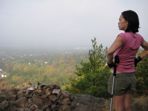
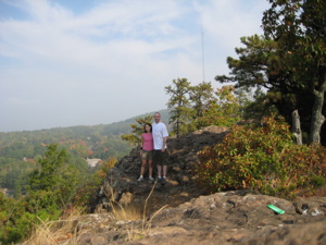
Just a couple minutes north we came to Pinnacle Rock. It seems like every trail in America has a rock named Pinnacle Rock, some better than others. Here is the best view from the Metacomet’s:
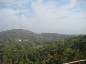
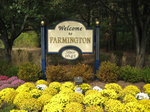
Yup, there are those TV towers again! They were so close I could taste the electromagneticism. The Metacomet followed the ridge for a short while longer, descended gradually and entered the town of Farmington. We crossed a (relatively) deep little valley area, walked a bit further and stared up at Rattlesnake Cliffs. I’ll admit, they were moderately imposing.
Hoang and I took a little break and discussed building a zipline from the cliffs we just descended over to the ones we were about to go up and over. You read it here first! (It really would work… sort of like you see in every single Belize tourism film you’ve ever seen. Trust me.) The Metacomet has a lot of cliffs of basalt along its length and these were among the most impressive.
The trail sort of skirts them, but not so much that you lose site of the size of the cliffs. The guidebooks states, “turn left and pass through tunnel/cave formation.” Well, here is what a “tunnel/cave formation” looks like:
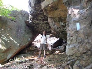
I think it looks better looking down upon it. It looks more tunnelly/cavey, don’t you think?
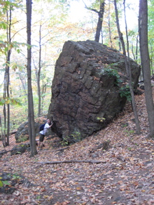
Immediately beyond that cool feature, we passed through a jumble of large boulders (like a Mahoosuc Notch for 5-year-olds. What’s a Mahoosuc Notch? A very difficult section of the Appalachian Trail just over the New Hampshire border in Maine famous – or infamous – for it’s boulder jumble. It’s actually great fun, though sort of stinks with a full pack on. Check out the first 10 or so pictures here. Cool, huh?”
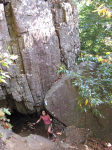
The Metacomet doesn’t offer quite that ruggedness, but it does offer some colorful local history, like Will Warren’s Den and Hospital Rock. After picking our way through a jumble of boulders, we came upon Will Warren’s Den.
Will Warren was a local Farmington scamp back in Colonial days who skipped out on church one Sunday. The town punished him harshly – so he punished them right back. He tried to burn the town down (so they say) and then ran away to the hills. Kindly Native maidens offered him shelter in a little cave – and here it is:
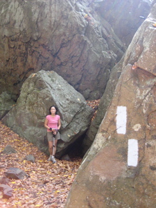
I love how Hoang is posing here.
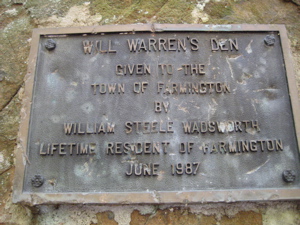
For more on CTMQ’s visit to Will Warren’s Den, Check this out. In the vicinity lies Hospital Rock. It took a couple years after this section hike, but I finally made it out to see Hospital Rock.
From a Hog River Journal article, “Hidden deep in the second-growth hardwood forest of Rattlesnake Mountain is an inconspicuous flat ledge of traprock. On it are carved 66 names of long-ago Farmington residents. This is Farmington ‘s “Hospital Rock,” and it marks the site of Eli Todd and Theodore Wadsworth’s smallpox inoculation hospital of the 1790s. It is a reminder of the terrible epidemics of another day, and of the efforts of local physicians to halt their spread.”
 Read all about my visit here.
We reached the summit of Rattlesnake Mountain in short order and thought about the possibility of seeing some actual rattlesnakes. Alas, they are wiped out of this area but I believe there is still a small population of Timber Rattlers over in South Glastonbury. And they definitely still live in the Northwest hills. It is a goal of Hoang’s to see a rattlesnake attacking a bear. Someday it will happen…
Just over the top of the hill, we finally reached the massive antennas. The trail actually passes right underneath the massive support cables and well within the humming steel buildings below the towers. Not the prettiest spot on the trail, but interesting nonetheless. (Two hawks were riding updrafts directly in front of us, so that was certainly pretty.)
 The rest of the hike was cake… apple cake to be exact. A nice contoured descent took us through an old, most likely abandoned orchard. The smell of apples was overpowering and really pretty nice. The trail was easy and we thought about collecting the fruit to make a “Metacomet Apple Crisp,” in Hoang’s words.
We crossed Route 6, which I only mention because it’s a pretty bad road crossing. Only two lanes, but a hilly bend just above the trail calls for running across the road. We survived. The trail passes above the very small Farmington Reservoir (I simply must mention them all at this point) and then pleasantly mosies through a pine/hemlock forest.
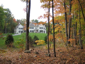
I knew we were approaching the cul-de-sac of Poplar Hill Road – home of mega millionaire hip hop star, Curtis Jackson, aka 50 Cent. Hoang and I wondered if he ever came out here to the peaceful woods to pen his rhymes and how funny it would be to stumble upon him with a bluebird on his shoulder and chipmunks eating out of his bullet wounds.
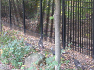 Alas, we did not find Mr. Cent in the woods but burst out onto his road and along his property. The trail does actually officially pass mere inches from his property along the wrought-iron fence that surrounds his manse. Some wild turkey were wandering around right in front of us as we peered in to catch a glimpse of the infamous place.
The house is big and incredibly ugly. Around here its still called the ‘Sisti Mansion’, originally built by one of the most corrupt businessmen in CT who was imprisioned for the Colonial Realty fraud. Later, the caretaker committed suicide there.
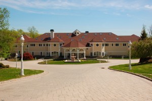 The house is approximately 50,000 square feet, has 52 rooms, and was bought by Tyson for $2.7 million in 1996 (the same year he knocked out Frank Bruno in the third round to win the WBC heavyweight title in Las Vegas). 50 bought it for $4.1 million. At least there’s enough room to accommodate 50 Cent’s massive entourage: The house includes five Jacuzzis, 25 full baths, 18 bedrooms, an elevator, two billiard rooms, a movie theater and a locker room.
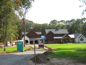
All very necessary, I’m sure. Right next door, finishing touches are being put on another silly mansion – for Fitty’s cousin I’ve heard. The second picture here is that house – sans the fence and guard house (so far).
 It’s not as if the others on Poplar Hill Drive are hurting financially by any means, but I just can’t imagine living next to Tyson and then 50 Cent. Though local rumor has it that he’s a pretty good neighbor and keeps it as low key as possible. He’s also sort of trying to sell it – there are several websites out there about that, some of which I’ve linked below.
Down the road, a left onto Mountain Road, and then a dip right across someone’s front lawn. An old man was out doing yardwork and gave me a hearty wave and smile – something I think he’s been doing to Metacomet Hikers for years and years. His old Irish Setter bounded towards us and I felt like we were in an Alpo commerrcial.
Does this mean that graffiti is okay?
Back into the woods and onto the Hillstead Museum’s property. Whoa! CTMQ crossover overload! I checked and the universe remained intact as we made our way over the rather groomed trail here. The trail was still pretty much flat, mind you.
 We passed yet another ridiculous mansion that I felt the need to take a picture of and then dipped down to a road crossing I’d been curious about for years. Literally.
While not quite a highway, Farmington’s Route 4 is a traffic nightmare. If feeds several town to the Interstate and the bottleneck caused by the 10 lane i-84 highway to the 2 lane Route 4 is just a mess every single day. The Metacomet Trail crosses this mess right where the magic happens; first a jughandle… check. Then a pleasant grassy area and finally the 4 lanes (in between the 10 and the 2). We waited a good five minutes before a safe break appeared; we made a run for it and lived.
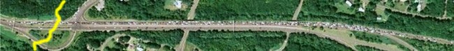
Note the traffic on Route 4. This is ever-present.
Almost done for the day, we walked along some fencing and a gas line and quickly hit Prattling Pond Road. Our car was spotted across Farmington Avenue at a Park and Ride that was it for the day. Wow… what a crazy 6 miles. I love this trail!
Finish!
…………………………………………………….
Section 8 Approximate Breakdown:
0.0 Miles: Blue oval sign on Route 372
1.6 Miles: Nike Missile Site
1.8 Miles: Pinnacle Rock
2.8 Miles: Rattlesnake Cliffs
2.9 Miles: Will Warren’s Den
3.1 Miles: TV towers
3.7 Miles: Old orchard
4.1 Miles: Route 6
5.0 Miles: 50 Cent’s house
5.7 Miles: Mountain Road
6.3 Miles: Prattling Pond Road
End
Links of Interest
Nike Missile program
Really dumb video of hike Plainville Nike site
Really cool video of Mahoosuc Notch
Excellent blog about 50′s tacky house


I liked this one-lots of twists and turns in it but mostly I cracked up at the line about “fitty’s” cousin!!!
Comment #1 on 10.27.07 at 4:37 amMy sister lives in the house that Googel, one of Sisti’s partners, owned. That’s all I can add…..
Comment #2 on 11.07.07 at 11:15 amJust rereading again because I’m obsessed with the Metacomet and I just saw the bit about the Belize zipline. I actually went ziplining/caving in Belize in July! Too funny! I frightens me how much you think like I do sometimes…. Just kidding! Keep up the great work!
Mindy
Comment #3 on 09.11.09 at 12:23 pmMy brother and I used to go hiking with the dog up at Pinnacle Mountain, the Nike Missile Base and Hospital Rock back in the late 70′s to early 80′s. He would toss cactus clippings around the area. He reasoned that they could survive year round in the yard at home (New Britain) they should survive out in the woods.
Comment #4 on 11.28.09 at 6:37 pmWhen I was a very young boy in the late 60s all the buildings of nike site were still up… We would go from building to building in and out of them kinda spooky and kool at the same time.. It was about a 2.5 walk from were I lived in Plainville. Years later they knock them all down. It brought back a lot of good memories!!!
Comment #5 on 10.26.10 at 12:55 amI just started doing this hike last summer – we start on Route 6 and do the 4.1 mile trek to 372 in Plainville. We park our cars on the edge of Route 6 and at some Medical Research building on 372.
This is such a fun stretch to do, amazing views, and not many other hikers make it out to this section. I highly recommend it to anyone!
Stephen, great write up, as always. I stumbled across your site a few months ago and I really love it. I live in Farmington, and I am just starting to branch out to more distant towns and discover some trails. I will be back soon to do some research from your posts!
Take care,
Comment #6 on 06.21.11 at 1:12 pmCraig
Just got back from this hike and used this blog as a guide. It was a huge help so thank you. I had been to hubeline tower a bunch of times and wanted to try something new. Had a blast! I saw an 8 foot black rat snake, which my wife didn’t care for too much. Also, there is a pretty cool view of Hartford overlooking an old quarry. It is just before the switchback and valley that lead to rattlesnake cliffs. At the top of the ridge, before you head down, you will see a telephone pole. Head slightly up and around the pole to the right. Can’t miss it. Just make sure to double back to the trail
Comment #7 on 10.15.11 at 3:25 pmhttp://youtu.be/mPt1nxrt-vQ?hd=1 video about hospital rock
Comment #8 on 06.10.12 at 8:02 am