Valley Falls Park Trails & Belding Path
A Walk Through the Valley of Falls
Multiple Trails, Vernon, solo
April 1, 2010
 Those who follow my hiking exploits know that I’m thorough both on foot and with keyboard. To officially complete the CT400(825) Club, one must not only hike all the main CFPA blue-blazed trails, but all the side trails mapped and described in the excellent CFPA Walk Books.
Admittedly, when I set out after work one day to knock off the Valley Falls Loop Trail in Vernon, I didn’t have high expectations. But as I’ve learned time and time again, my low expectations often yield exciting returns. Such was the case in and around Valley Falls Park.
I had hiked the Shenipsit Trail through the park a couple weeks prior with my friend Dennis, who happens to live less than a mile away from Valley Falls Park. The Shenipsit follows a converted rail bed for 2 miles into the park, then heads down to the parking area next to a lake and an old mill race before continuing north out of the property – and into the Belding Wildlife Management Area. The Walk Book only describes the blue/yellow blazed Loop trail, but I was feeling frisky and decided to check out the park a bit more thoroughly.
And I’m very glad I did. In fact, not being aware of all the ins and outs of private land ownership and other difficulties, I would humbly suggest that the trail maintainers for the Shenipsit think about re-routing the main trail to take in some nearby areas instead of simply following the rail bed.
 In short, my hypothetical re-route would leave the Shenipsit and head southeast along the rail bed into Freja Park and take in Squaw Cave (CTMQ report here), then return to the current trail along the rail bed heading north to Valley Falls, but instead of heading down to the pond, head west up Box Mountain to hike along the top of the cliffs before heading down to the lake and north out of the park.
Maybe someday; for now, there’s no reason you can’t follow that hike.
…………………………………………………….
Valley Falls Park History From The town of Vernon website – long, but interesting.
 Near the southern boundary of the Town of Vernon, a picturesque, tumbling stream cascades down from the hills of Bolton, winding its way over boulders and around steep outcroppings of rocks to join the Tankerhoosen River. The area it drains is known as Valley Falls. Hills rise sharply on both sides of this hurrying river let, creating a storybook type of valley. This part of Vernon is located on the very edge of the Eastern Highlands of Connecticut where the land drops off quickly from an elevation of several hundred feet to the sandstone valley below which averages only forty feet above sea level.
In Colonial days a busy factory was located on the stream at the point of the greatest drop, for all mills were run by water power at that time. In 1740 Thomas Johns erected a sawmill just above the pond . In 1790 Joseph and Samuel Carver together with Zekiel Olcott of Bolton bought the mill and its water rights and transformed it into an oil mill. Here they pressed linseed oil from the seeds of the flax plant which was grown extensively for its- linen fiber. When cotton and wool fabrics made by machine took the place of homespun “linsey-woolsey”, the mill was closed. During its last years it was converted into a grist mill and was operated by Charles Lass. Its foundation can still be seen amid the undergrowth which has since grown up in the valley.
 In 1849 the Hartford, Providence and Fishkill Railroad began to construct a line of tracks from Manchester to Willimantic. Railroads generally followed along the sides of streams but Valley Falls presented a different problem. Box Mountain rose sharply from the plain, hence a shelf or terrace for the tracks had to be carved out of the side of the hill making the stretch from Vernon to Bolton the most expensive part of the operation. To obtain a gradual ascent a huge mound of earth had to be up. This man-made hill covers the hundred and eight foot tunnel on Tunnel Road (See this tunnel via a crazy quirk in Google Maps). In its day this was a great engineering feat, for all the work was done by hand with pickaxes and shovels and horse or ox drawn carts. Newly arrived immigrants from Ireland worked on this project. The sandstone blocks used in building the tunnel were cut and laid up in the form of thirty keystone arches. The surface of each block was textured with a hammer and chisel.
The first train passed over this route in 1850. It was a very precarious run for stones on the side of the mountain above the tracks were often jarred loose and fell down on the tracks. The Railroad Company employed a steady track walker to go over this section of track each  time a train passed . It was a hard uphill pull for the heavy steam locomotives to get to Bolton Station, then called “Quarryville”. At times the train seemed to just crawl along its shelf cut in the side of Box Mountain. Thus, Valley Falls became a “station” for hobos who could easily jump on to freight trains as they toiled along and in this way they got a free ride. Passengers riding the train from Willimantic to Vernon Depot got a thrill for at 301 tons, the engineer would disengage the engine and let the train coast down through the valley at breakneck speed thoroughly frightening even the most composed of its riders.
One of the early Colonial homes along Valley Falls Road is located opposite the pond. In the late 1890′s it was owned by Count Muncho, a Hungarian nobleman who lived the life of a gentleman farmer there. It was he who built the large, elaborate stable at the crest of the hill to house his fine horses. The interior walls are made of matched boards and its stable accessories are custom made.
The Count, some recall, was a tall, well-groomed man with a neatly trimmed Van Dyke beard, who sat up straight in the narrow carriage with a seat just wide enough for two, himself and his Great Dane dog. This turnout was drawn by a lovely dappled – grey horse. At times he rode his saddle horses along the trails through the woods nearby. The Count was responsible for bringing other Hungarian families to Vernon to work as masons, cooks and caretakers on his estate. Legend has it that he suddenly auctioned off all of his farm tools, sold his property and went to Hollywood where he became a successful movie producer.
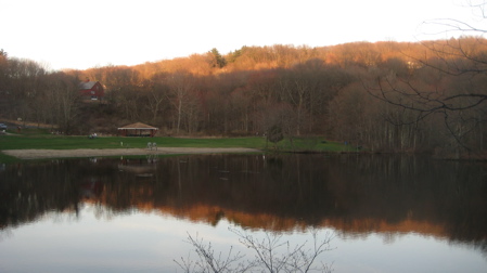
Dr. Charles Beach acquired the little Colonial house at this time. It was used for many years as the home of the caretaker for the Beach estate. The stream and Valley Falls pond were also a part of the Beach property. Here the doctor’s family fished and swam in summer and had ice cut on the pond in the winter. As the family grew up they built houses on the estate as well as a guest house close by the family mansion with its famous sunken rose garden. Horses, cows, chickens and a large vegetable garden occupied other parts of this estate. Several years ago this property was put up for sale. The town bought the pond and some of the surrounding land for a recreation area.
Now if only every town park in Connecticut had such great histories and write-ups…
…………………………………………………….
Valley Falls Loop Trail (Eastern Loop), 3.7 Miles total
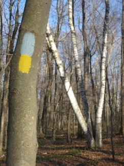
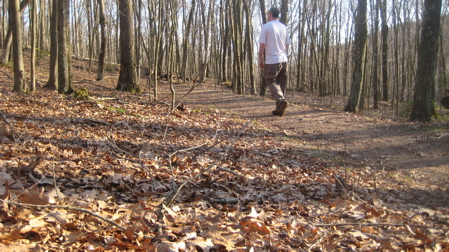
 This is the only trail one “must” complete alone one’s way towards the CT 400(825) Club. It’s actually two loops, east and west of the Shenipsit Trail. I started with the eastern loop, clockwise.
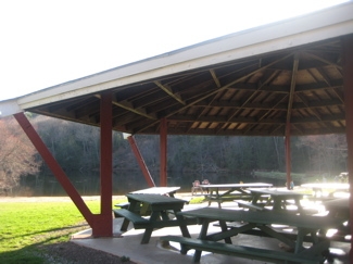
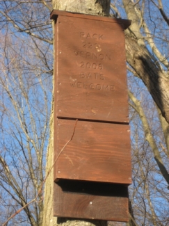
From the parking lot, it starts at the northeast end of the pond near the picnic pavilion and initially traipses through a meadow outfitted with a bunch of very nicely made bat houses. (They were an Eagle Scout project, I think.)
Once through the pleasant meadow, the trail heads uphill and leaves behind most of the park-goers, through some timbered area with very strangely laid down cut trees. I’m quite sure this is done for some forest management purposes I’m not aware of, and I’m sure it makes sense, but it looks very odd when freshly laid.
Once atop the unremarkable hill, the trail swings south and west, crossing a series of seasonal brooks. Ridiculously, I dropped my water bottle into one of these while stumbling across it. (Moderately funny story: I’ve never bought a bottle of water in my life but was offered  one at a CTMQ stop the day prior. I only accepted the bottle because they are now worth a nickel in Connecticut. So to me, it was like the guy said, “Steve, do you want a nickel?” So of course I said yes. Then I brought it along on this walk because it was easy to carry in my hand… Until I infected it with giardia. Oh well.)
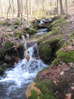
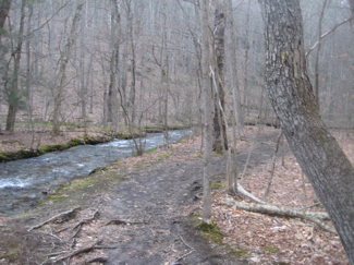
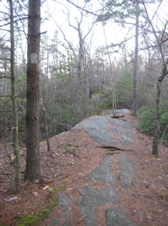
After that, the trail contours around a hill and ultimately winds up down in some swampy areas near Railroad Brook before turning north along the brook and then steeply up the banking to join the Shenipsit along the old railroad bed.
It’s not the world’s most exciting trail, but my hike gets better. Instead of rejoining the Shenipsit to repeat the mile I did a few weeks earlier, I continued along the brook via the yellow blazed Railroad Brook Trail.
…………………………………………………….
Railroad Brook Trail, 2 miles
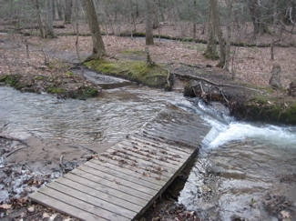
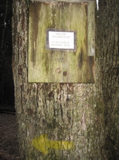
 No way is this trail 2 miles long. I would guess it’s around 1 mile, but that’s not important. This yellow-blazed linear trail winds along with, you guessed it, Railroad Brook. And Railroad Brook parallels the Shenipsit Trail, often about 50 feet below it.
An enormous amount of effort has gone into maintaining this trail, as there are at least 15 bridges spanning the decent-sized brook. A brook, which in times of rain, often overflows its banks taking out these bridges. And yet, most are all still intact and holding up well. Valley Falls Park is to be commended.
I enjoyed the walk along the brook. Heck, if you’re bored with the Shenipsit at this point, feel free to hop down to this side trail and get your feet wet. There were a bunch of dopey Vernon kids (maybe they were from Rockville, I don’t know) smoking and cursing and running around the area like a bunch of idiots.
…………………………………………………….
Valley Falls Loop Trail (Western Loop), 3.7 Miles total
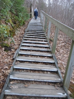
A whole mess of trails all come together around the stairs leading to (and from) the pond. At the top of the stairs, the Valley Falls Loop  Trail continues north along the rail bed for about half a mile before turning sharply west and up the northern slopes of Box Mountain. The ascent is fairly gradual and the trail crosses over into some Vernon Land Trust Land.
Once atop the ridge, the blazes become somewhat difficult to follow so I lost the trail for a moment and found myself, rather oddly, standing at the end of a nicely maintained soccer field.
A soccer field on top of a (small) mountain in the middle of the woods. There are no roads leading to the field; just a rutted dirt road at the extreme western end which leads to a neighborhood. The whole scene was really, really weird.
Who plays games here? Why is this field here in the first place? It’s very disorienting. It’s called the Boulder Ridge Soccer Field and… That’s all I can tell you. I can almost see a well-hit errant shot on goal making its way through the trees on top of the ridge and then falling down the cliffs all the way to the rail trail 200 feet below.
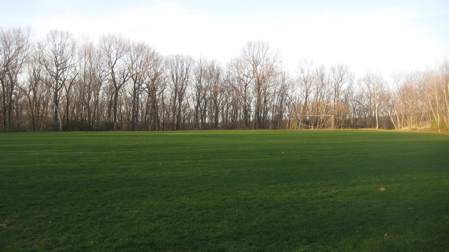
Which, upon reflection, could be pretty funny.
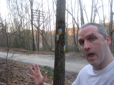
I found the blue and yellow blazes again and followed them past an orange trail, across a Jeep road, up to the ridgeline again and on to a While blazed trail.
(The loop trail continues down the mountain back to the Shenipsit right about where it descends those steps to the lake.)
Valley Falls Loop: Done!
…………………………………………………….
Lookout Trail, white-blazed, 0.6 miles
 I’m thinking their mileages on the brochure are out-and-back totals. Though short, this is the best walk in the park. It’s wonderful.
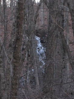
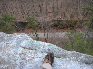
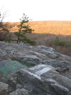
It merely follows the ridgeline south atop the cliffs that loom above the Shenipsit below. The rewarding view at the end (and a few along the way) are definitely worth any extra effort to get up here. And really, the effort isn’t all that much as I passed a young woman wearing flip flops on the ridge.
Once I reached the view, I sat for a while and took it all in. It’s nice… Valley Falls Park is nice.

But as nice as it is, I think I like the Belding Wildlife Management Area a little more…
…………………………………………………….
Belding Path, yellow-blazed, 0.5 Miles
You can read about the Shenipsit through the Belding area here; easily one of the best sections of that trail. It’s particularly beautiful and tranquil.
This short little side trail which connects out to Reservoir Road and a very nice hiker lot is interesting in that there are interpretive signs along the entire path. And these signs aren’t your usual “Forest succession” and “Wooly Adelgid” signs, but are unique and interesting.

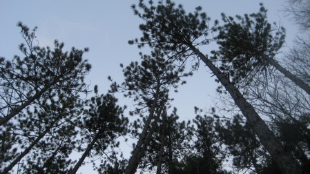
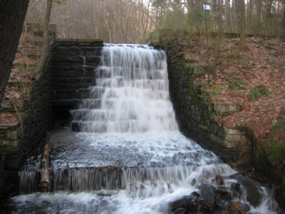
The trail walks under huge white pines, red pines, pitch pines and even some living hemlock. It passes by an old millrace which is one of the finest crafted ones I’ve seen around the state.
My hike was at dusk and I sort of jogged the whole thing, but I loved it.
Vernon, you have a treasure in the Belding Wildlife Management Area. I wonder how many of you know that?
The nearby Risley Reservoir Loop (part of the Shenipsit System)
Peter Marteka’s account
Belding Wildlife Management Area


i brought my friends to the belding area today. its the best =D great article, by the way. i sent it to one of my hikey friends. thanks!
Comment #1 on 04.17.11 at 9:34 pmgood article man. stacey linked me to it. I hike to valley falls a lot from a place my friends and I dubbed “Floodplain Forest”…not sure what the actual name is but we enter on reservoir road off exit 67…it’s a decent hike if you haven’t tried it, about a mile and a half from floodplain to valley falls.. Good inclusion of the snip trail in your article too..I grew up in tolland next to that lake and hiked down there before it was an official state trail.
Comment #2 on 04.17.11 at 10:02 pmjust noticed the very end of the article and the inclusion of floodplain. even better
Comment #3 on 04.17.11 at 10:11 pm