Section 2: Look! We Took Crooked Brook!
Metacomet Trail: Section 2
Orchard Road Turnoff – Summit Wood Drive, 1.4 miles
May 12, 2007
 Since these lower sections of the Metacomet Trail are so near our workplace, we had originally planned to just bang out this short section after work one day. Then we both got busy and didn’t really have the time… that, and the thunderstorms on the appointed Friday. Oh well, it was a good idea whose time will certainly come.
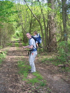
So instead we planned to do it on a beautiful Saturday – with our beautiful 15 month old son, Damian (hence the Dr. Seuss theme of the title and captions). This would be his first hike during which he would be aware of his surroundings, and we figured the short length would be a good first test. If he was a pill, it would be over in half an hour anyway.
After checking out the Berlin Historical Society Museum a few miles north up Route 71, we parked one car along SummitWood Drive and drove the other to where we left off last time: The intersection of Orchard and Kensington Roads where the trail first goes off-pavement. As we were situating Damian in the backpack-carrier-thing, a Volvo wagon pulled up behind us to squeeze into what wasn’t actually a parking spot. Strange… “This can’t possibly be a highly trafficked section of the trail,” we thought. Especially with much cooler parts of it to hike just a few miles away.
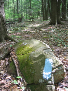
Hop on Top of Pop!
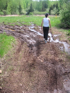
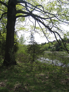
Out popped a mom and her two athletic looking daughters with directions in hand. Hoang and I were quite surprised to have company on this admittedly silly little hike. We let them go ahead of us, took the hike-starting picture, and we were off. The trail here is an abandoned jeep trail which has been blocked off by large concrete blocks (which you can barely see in the background of the picture below.) However, it’s very apparent that motorcycles, at least, have made their way through to the trail. The erosion wasn’t too bad though and before we knew it, we were just east of a fairly large pond.
Check! A heck of a pecked TimbuckTeck!
The somewhat serene scene was broken by the rancid stench of swamp gasses that hit us just past the pond. We crossed a gas pipeline field area that was muddy and swampy and quite stinky. Damian didn’t seem to care as he continued to play drums on my head. We saw the first evidence of deer here, with many hoof prints in the mud – I have a feeling we’ll see plenty of white tails on this whole adventure, as they are quite a problem as suburbia encroaches more and more on the forested lands.
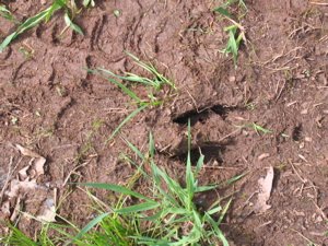
Oh dear! A deer was clearly here!
Which also makes this entire trail so interesting in a way; it twists and turns to avoid suburban developments as best as possible. This little section will probably be gobbled up in a few years with more McMansions. Perhaps that’s why, in a bit of foresight, the blue blazes diverge left away from the jeep trail shortly past the clearing (and the trash heaps) and squiggles its way down to Crooked Creek.
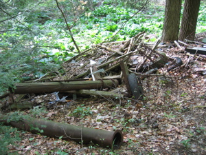
The Once-ler dumped this pile, upsetting the Lorax!
Of course, when I say “down” I mean, “lose about 20 feet of elevation.” The trail quickly became very faint, but what the walk lacked for in “trail,” it made up for in blue blazes. My word, they seemed to be on every tree five feet apart! My guess is that 95% of those who actually make their way to this area just stay up on that jeep trail which essentially winds up in the same spot. So what are they missing?
Mud dud fud crud. Tut rut but nut
Crooked Creek, that’s what. The trail itself is rather crazy for this 3/4 mile or so. It appears to have recently been (overly) blazed in an effort to avoid the expanding Berlin suburbs and just twists and turns along the creek willy-nilly. This was great fun and all… but I had a 1 year old on my back and had to be wary of low branches as well as insuring myself against falling on a wet or wobbly rock. Hoang hiked along behind me, probably ready to leap to Damian’s aid if I started to fall over.
 I imagine this section is a huge mess during or just after a rainstorm, but aside from some boggy areas and an increased bug count, it wasn’t too bad for us. After a while, the trail veered right up a small 25 foot ridge back towards the jeep trail. As we approached, we heard the group of three women who had stayed on the nice wide trail. We burst forth from the woods just as they passed us and began following them dutifully.
Oops. I have no idea why we followed them, but we did – and we shouldn’t have. Once we hit a HUGE power line clearing, we realized we hadn’t seen any blue blazes for a while so we backtracked to where we came out of the woods. At this point, Damian finally started complaining a little bit, as if he knew we’d messed up. Aha, the Metacomet Trail passes right over the jeep trail and up to the top of the tiny little hill. Here, we found a lot of exposed volcanic rock, displaying the ancient history of this ridge. There are several unnecessary switchbacks and a few sort of steep short little scree covered descents. There were more sharp little S curves and other quirky little bends and double-backs.
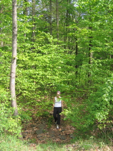
Hoang still strong and hike’s end, not long!
Then it hit me… the trail was merely trying it’s darnedest to avoid the houses that were on either side of it through the woods. Now that the trees were foliated, we didn’t see the huge houses around us, but we could hear the kids playing and barking dogs. Finally, a sharp left turn, up a little roadstone debris pile, and we were standing on Summit Wood Drive, right next to our car.
Perhaps surprisingly, Hoang and I actually both enjoyed this short little jaunt along Crooked Brook. It was just so strange with the lack of a discernable footpath for a large portion of it – it seemed almost like an adventure more than a hike at times, even if you’d have to be blind to lose the blue blazes along the creek. Damian was good for almost the entire hike, only whining a bit at the end and the weather was absolutely perfect.
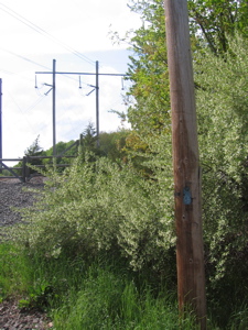
Official stop point of Section 2; Trail crossing Summit Wood Drive in Berlin
…………………………………………………….

Section 2 Approximate Breakdown:
0.0 Miles: Orchard and Kensington Road Intersection
0.1 Miles: Pass east of pond
0.3 Miles: Cross clearing
0.4 Miles: Veer left, following blue blazes off Jeep road
1.0 Miles: Veer right away from Crooked Brook
1.1 Miles: Cross straight over old Jeep road
1.2 Miles: Reach hill top
1.4 Miles: Cross Summit Wood Drive
End
Links of Interest
Town of Berlin hiking
The Lorax Game
The EvenFlo Trailblazer


Leave a Comment